-
 The following schools will be closed Tuesday: Florida A&M University, Leon, Franklin, Gulf, Madison, Jefferson, Wakulla, and Taylor County Schools.
 -
 The week starts with severe weather, including the chance for a tornado or two, damaging winds, and hail for the Florida Panhandle. Flash flood risk increases for Tuesday along the I-10 corridor.
 -
 More severe weather is expected in Tallahassee today. Heavy rain and strong storms are expected. The National Weather Service has issued a tornado watch for the area until 7 p.m.
 -
 Tallahassee area residents are continuing to recover from the strong storms and tornadoes that devastated parts of the city Friday. The latest estimates Sunday evening showed power had been restored to about 91% of impacted customers.
 -
 Sail High School, Sable Palm Elementary and Lively Tech are closed Monday. All other Leon County schools are open. But during an online update Sunday evening, Superintendent Rocky Hanna said no transportation will be provided.
 -
The storms this morning are causing closures and delays for schools in the surrounding area.
-
 Multiple rounds of potentially severe thunderstorms are possible over Florida's Panhandle and North Florida Thursday afternoon through Friday night. Interests in these areas should continue to seek forecast updates, and are urged to heed any warnings issued for their location.
 -
 Hurricane season officially ends on November 30, however, recovery efforts are still underway. This year Hurricane Idalia caused an estimated $3-to-5-billion in losses when it crashed into the Big Bend at the end of August. Now, residents are looking to the legislature for more help during the upcoming session.
 -
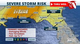 An approaching cold front will help provide the atmosphere with extra lift and could lead to strong storms through Wednesday in North Florida and the Panhandle.
 -
 Florida A&M and Florida State University have canceled classes for the rest of the week as Hurricane Ian moves further into the gulf and threatens the Gulf Coast of the state. Tallahassee Community College is continuing business as usual as more area school districts announce closures.
© 2025 WFSU Public Media
WFSU News · Tallahassee · Panama City · Thomasville
Play Live Radio
Next Up:
0:00
0:00
Available On Air Stations


