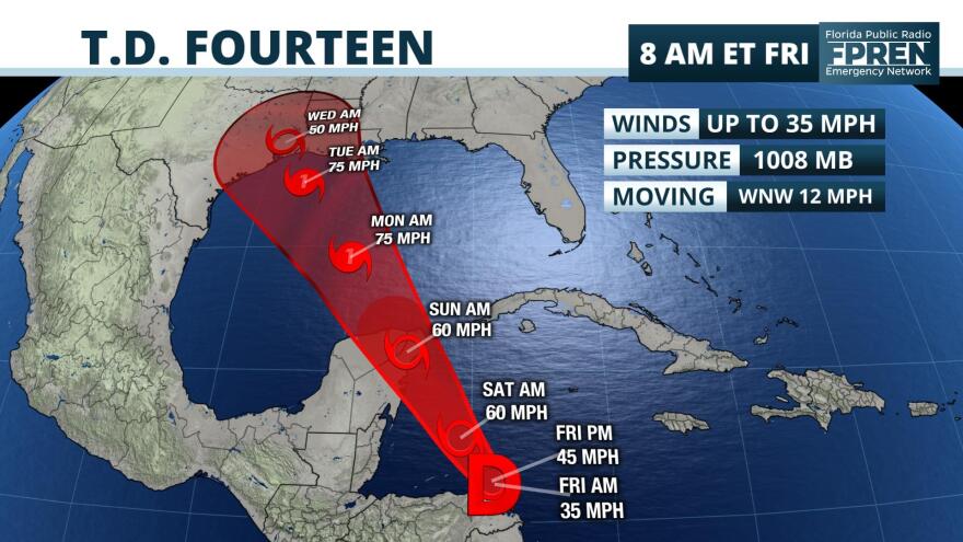
Tropical Depression 14 is nearing tropical storm status as it passes near the coast of Nicaragua and Honduras. It poses a direct threat to Mexico's Yucatan Peninsula this weekend, and likely the central or western Gulf coast of the United States during the middle of next week.
The depression is moving toward the west-northwest near 12 mph and was expected to become a tropical storm late Friday morning or Friday afternoon according to the official forecast from the National Hurricane Center. The tropical storm could be near hurricane strength on approach to the Yucatan Peninsula Saturday night, and for this reason, Hurricane Watches are posted in the Cancun area.
What is likely to be a tropical storm is then expected to enter the south-central Gulf of Mexico Sunday afternoon. The warm waters of the Gulf of Mexico may allow the system to become a hurricane as it approaches the upper Texas or Louisiana coastlines some time on Tuesday. There is some possibility the timing of the storm will change, particularly if it interacts with Tropical Depression 13, which may be near Florida at about the same time.
The National Hurricane Center is urging interests along the central and western Gulf coast to monitor the system over the coming days.
Copyright 2020 WUFT 89.1. To see more, visit . 9(MDA4MzU1MzUzMDEzMTkyMzAwMzY5MjY1Mw004))


