-
Climate scientists and decision makers from lawmakers to business leaders will discuss ways to speed up climate adaptation for threats posed by rising seas and extreme weather events.
-
A cold front will bring the risk of strong storms, which could be capable of producing wind gusts of up to 60 miles per hour and tornadoes.
-
A study of several cities in Florida shows an average rise of as much as 3 degrees in the past century.
-
Severe storms could bring damaging winds and tornadoes to the state ahead of a powerful midweek cold front.
-
The potential for several rounds of strong thunderstorms comes only a few days after the last storm system.
-
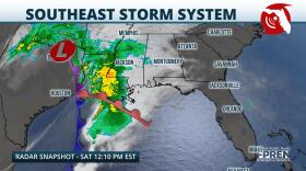
A storm system impacting the Central Gulf Coast is expected to create unsettled weather in Florida's panhandle Saturday night and early Sunday. Damaging wind and isolated tornadoes will be possible as a broken line of thunderstorms tracks through the region.
-
A large non-tropical area of low pressure will likely develop in the southwestern Atlantic this weekend and track toward Florida or the southeast U.S. If certain conditions are present, development into a sub-tropical or tropical system is possible early to mid-next week.
-
Advocacy groups say the nation’s disaster response system isn’t ready as climate change leads to more extreme calamities.
-
"As we increase the temperature of the atmosphere... the air that is all around us can hold more water," says Daniel Gilford of Climate Central. "There's been about a 10% increase in atmospheric moisture and rainfall associated with Hurricane Ian."
-
A legislative budget panel this week gave Gov. Ron DeSantis millions more dollars to pump into storm recovery projects, two weeks after category 4 Hurricane Ian landed in Southwest Florida and crossed the state. Ian landed nearly 4 years after category 5 Michael hit the Panhandle, where recovery continues.
Play Live Radio
Next Up:
0:00
0:00
Available On Air Stations


