-
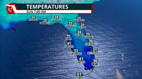
 Record temperatures over the weekend are expected across Florida just before a front stalls and brings much-welcomed rains.
 -
 This week's rain was welcome, and we need a lot more. Tallahassee is in a rainfall deficit of more than 20 inches. We hear the forecast and more on Speaking Of.
 -
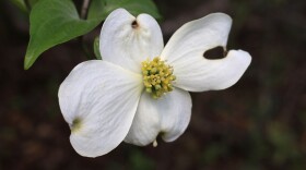 From high temps to hard freezes, Tallahassee weather can be unpredictable. An expert tells us how to bolster our gardens to handle weather extremes.
 -
 On Speaking Of, we talk high power loads, winters that are getting less cold, and the climate outlook for our region.
 -
 This will not be the coldest air mass of the season, but it could be the coldest air mass felt in over a decade for some. Some flurries are also possible.
 -
 The cold blast has brought more than just cold to Florida. Many are dealing with low tire pressure, and it's all about the weather.
 -
 The big winter (and popular) topic is dusted off very early this season as frigid air plunges south for Veterans' Day. But what is the polar vortex, exactly?
 -
 A significant frontal boundary will usher in the coolest air of the season with temperatures reaching the 40s across the Interstate 10 corridor.
 -
 It’s been a year since the Tallahassee tornadoes downed trees and damaged structures.Residents of the hard hit Indianhead Acres community joined us for Speaking Of.
 -
 Saturday marked one year since severe storms and tornadoes ripped through Tallahassee, devastating some neighborhoods and leaving a deep scar in some parts of the community. Regan McCarthy takes us back to the days following the storm.
© 2026 WFSU Public Media
WFSU News · Tallahassee · Panama City · Thomasville
Play Live Radio
Next Up:
0:00
0:00
Available On Air Stations


