-
 The downpours and storms continue to impact the Panhandle after 24 hours. The storm is finally on the move, and the front will push through the state.
 -
 An extensive Gulf system increases the chance for Sunday showers and storms along the Panhandle. Some could turn severe. More ahead.
 -
 The Panhandle and North Florida are most likely to experience severe storms between Tuesday night and Wednesday midday. Isolated storm for Central Florida will also be possible.
 -
 Some isolated spots received slight relief from the drought courtesy of the low pressure that dissected the state earlier this week. Can we expect more soon?
 -
 Florida received a fair coating of rain on Monday with that low-pressure system that dissected the state. Many received around 2 inches, while the Keys flooded. This could put a dent in the drought.
 -
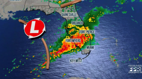 The same system that has produced torrential rains along the Gulf Coast is now moving toward Florida. This storm will affect the entire peninsula, but the highest rainfall will stay over South Florida, probably producing some flooding.
 -
 Timing and exact location of the storm's center could shift slightly, but as of Friday, South Florida could have some spots with 5 inches of rain through next Tuesday. Enjoy the weekend before the downpours arrive.
 -
 It's an impact weather day across Florida as a strong cold front pushes through. The front will bring some storms to the Panhandle and North Florida and scattered showers to the southern half. Cold temperatures to end the week and will stay below average for several days.
 -
 Damaging winds and a couple of tornadoes are possible on Saturday and Sunday. Make sure to have at least three ways of receiving weather alerts.
 -
 If you are prone to allergies buckle up! Hay fever season is getting a jump start after warm weather surges across Florida.
© 2025 WFSU Public Media
WFSU News · Tallahassee · Panama City · Thomasville
Play Live Radio
Next Up:
0:00
0:00
Available On Air Stations


