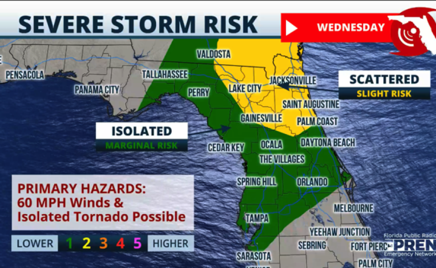
Parts of North Florida are under a slight risk for severe weather on Wednesday. Central Florida could also see some isolated severe storms as a cold front pushes through the region. The cold front will be passing across Florida from north to south. It’s associated with a very large low-pressure system heading toward the northeast. This low-pressure system extends over 1,200 miles, bringing an enormous wind field across the Great Lakes, the northeast, and even south through much of Florida.

Timing of severe weather
The Florida Panhandle will likely experience severe weather overnight on Tuesday into Wednesday morning. Although the risk for severe weather diminishes as it moves east, it will still be present in the morning hours between 8 a.m. and 12 p.m. from Tallahassee through Jacksonville along the I-10 corridor and for surrounding areas. Gainesville could also see an isolated storm or two that could produce damaging wind, and an isolated tornado cannot be ruled out.

Across Central Florida, the thread for isolated thunderstorms will arrive after 11 a.m., and the storms will push south between noon and 3 p.m., likely located in Osceola County by 2 p.m. Severe weather in this region will not be as prolific but an isolated severe thunderstorm could still develop. Remember that even with an isolated severe storm, there could be damaging wind gusts of at least 60 mph, and a storm could become tornadic.
We’re not forecasting storms across South Florida, but there could be some isolated downpours as the front pushes through. Much of its moisture will dissipate as the cold front moves through Broward and Miami-Dade counties.


After the front sweeps through Florida
The wind will remain strong on Thursday along the Peninsula. The seas will also be rough along the Gulf and Atlantic coasts. Dangerous marine conditions will prevail through late Thursday, mainly from the north-northwest. High pressure will build from the west, and winds will slow down on Friday. But as the high-pressure system migrates east, the winds will shift mainly from the south-southeast on Saturday, moderating the temperatures and humidity will be increasing. Temperatures will bounce from 10 to 12 degrees below average on Thursday afternoon to around average, in the low-80s, across Central Florida on Saturday.
For North Florida and the Panhandle, temperatures in the afternoon on Thursday will be in the mid-60s, with a fresh cool wind, strong at times. By Saturday, temperatures will be in the mid to upper-70s, but the chance for showers will return. Expect a cold night across the I-10 corridor, along the Panhandle, on Thursday night into Friday morning, with some cities dropping to the mid to upper-30s. South Florida will be mild; highs will range between the low to mid-70s on Thursday, with north winds between 10 to 15 mph and some gusts that could exceed 25 mph at times. By Saturday, the temperatures will bounce back to the low-80s, and the winds will be up to 12 mph.