Ian has become the second major hurricane of the 2022 season, and intensification is projected to continue.
As of the 5 AM update from the National Hurricane Center (NHC), Ian is a strong category three hurricane with sustained winds of 125 miles per hour. It’s center of circulation is over the western tip of Cuba and its forward motion is northward at 12 miles per hour.
Conditions over the southeastern Gulf of Mexico will be supportive of thunderstorm development, and Ian is expected to strengthen further, as its core pushes off Cuba and over the warm Gulf waters late Tuesday morning.
Forecast models are still showing fluctuations in projected track, and the official forecast now is favoring a rightward shift: The core of the storm should remain off the Lee Island and Sun Coast Tuesday and Wednesday, before making landfall with the Sun Coast sometime on Thursday.
Interests along the entire Florida Gulf Coast should remain vigilant, as the track forecast could reflect additional changes over the next 24 to 72 hours.

A summary of tropical alerts in effect are as follows:
- Tropical Storm Watch: Forgotten Coast and Big Bend from Indian Pass to the Suwannee River, First Coast from Jekyll Island in Georgia to the Volusia/Brevard county line. Jupiter Inlet to Deerfield Beach
- Hurricane Watch: Tarpon Springs to the Suwannee River
- Tropical Storm Warning: Lower Keys from Key West to Seven Mile Bridge, Flamingo to Bonita Springs, Tarpon Springs to the Suwannee River, Jupiter Inlet to the Volusia/Brevard county line, Lake Okeechobee
- Hurricane Warning: Bonita Springs to Tarpon Springs, Tampa Bay, Dry Tortugas

In addition to tropical storm and hurricane force winds impacting the Florida peninsula, clusters of tornado outbreaks are possible over the next few days as Ian approaches and makes landfall.
The region south of I-4 has an increasing risk for tornadoes Tuesday and Tuesday night, and that threat shifts to encompass most of the peninsula Wednesday, and East-Central Florida on Thursday.

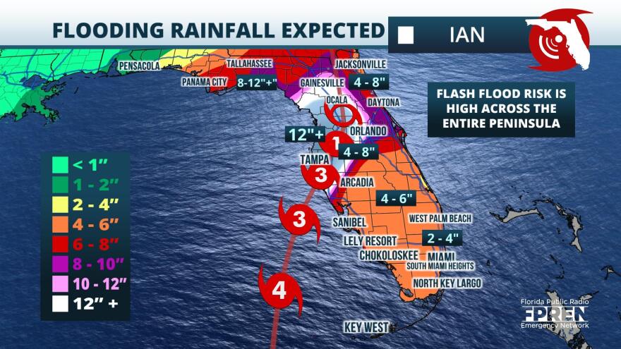
Ian is also expected to produce flooding rainfall, especially over the I-4 corridor where 10 to 15 inch accumulations are possible over the next five days. In the Tampa Bay area, locally up to 20 inches could fall. This precipitation, coupled with five to 10 feet of storm surge in the Tampa-metro area, will likely produce catastrophic flooding for the region.
Residents are urged to continue monitoring the forecast and to have multiple ways of receiving weather alerts. If emergency managers issue evacuation orders, heed their advice and relocate to a safe location.
For interests in South Florida, hurricane plans should be finalized, as conditions are forecasted to begin deteriorating as early as Tuesday afternoon.
Copyright 2022 Storm Center. To see your local forecast, click here.


