The 2026 Atlantic hurricane season begins June 1, and preseason outlooks suggest activity across the basin could be more subdued than average.
During the 2025 season, 13 named storms formed, which is near the long-term average, but no hurricanes made a direct landfall in the United States, making it a relatively quiet year for the Southeast.

The near-average activity occurred during a neutral phase of the El Niño-Southern Oscillation, which is commonly referred to as ENSO.
This climate cycle, which includes both El Niño and La Niña phases, plays a significant role in shaping hurricane activity around the globe.
Heading into 2026, forecasters expect El Niño conditions to develop across the Pacific Ocean.
El Niños are known to lead to increased wind shear across the Atlantic, Caribbean and Gulf, which creates a more hostile environment for tropical cyclone organization.
Climatologically, the first named storm of the Atlantic season typically forms around June 20, while the first hurricane usually develops by mid-August.

Changes to forecast products
The National Hurricane Center announced several updates to its forecast products ahead of the season, designed to improve how storm risks are communicated.
One of the most significant updates involves the forecast cone, which will now display inland Tropical Storm and Hurricane Watches and Warnings.
Previously, the cone only showed coastal warnings, but testing during previous seasons found strong support for including inland alerts.
Forecasters contend that changes will better convey the impacts of tropical cyclones, which can extend hundreds of miles from the coast.
The size of the forecast cone has also been slightly reduced because of improvements in forecast errors.
At 24 hours, the cone is now about 39 nautical miles wide and expands outward to roughly 200 nautical miles at five days.
Additional changes will also take place with the agency's daily graphical tropical weather outlook.
Systems with little to no chance of development will now appear as a gray “X,” replacing the previous use of a yellow symbol. The yellow “X” will remain for disturbances with at least some chance of development.
Experimental products, including an elliptical cone and enhanced marine graphics, will also be tested during the 2026 season.
2026 Atlantic hurricane season predictions
Colorado State University outlook: The first outlook from Colorado State University for the 2026 hurricane season suggests that the Atlantic basin could be in store for below-average activity, with 13 named storms, six of which are expected to become hurricanes and two reaching major hurricane status.
“So far, the 2026 hurricane season is exhibiting characteristics similar to the 2006, 2009, 2015 and 2023 seasons,” Phil Klotzbach, a CSU senior research scientist and lead author of the report, stated.
“Our analog seasons have ranged from well below-average Atlantic hurricane activity to somewhat above average. While the average of our analog seasons is somewhat below normal, the large spread in observed activity highlights the high levels of uncertainty that typically are associated with our early April outlook.”
North Carolina State University outlook: For the second year in a row, experts at North Carolina State University expect the hurricane season to fall in line with average. Instead of releasing a single figure, they provide a range for named storms, hurricanes and major hurricanes. In 2026, the group expects 12 to 15 named storms, six to nine hurricanes, including two to three major hurricanes.
University of Arizona outlook: University of Arizona's outlook is the most aggressive of any major institution. Forecasters expect 20 named storms, nine hurricanes and four major cyclones. Even though El Niño will be present, forecasters at UA expect water temperatures to remain surprisingly warm across the Atlantic, leading to increased activity.
“The big story with this season will be the possibility of a very strong El Niño, in fact the highest SST values in the Niño 3.4 region in our model. This makes our forecast of an active year surprising, but another factor to consider is the high forecasted SSTs in the Atlantic, which are among the highest in the model. The setup feels similar to 2023, though the Atlantic SST anomaly is not as high and the ENSO anomaly is higher. Our forecast this year is very similar to 2023, where the observed values fell within our ranges for all categories except major hurricanes,” forecasters stated.

2026 Atlantic hurricane storm names
Twenty-one names make up the list used to identify cyclones across the Atlantic basin.
The list of names is repeated every six years and is maintained by the World Meteorological Organization.
The last time there were cyclones named Arthur, Bertha and Cristobal was in 2020.
The WMO removed the name Laura following its devastating strike along the Louisiana coastline as a Category 4 hurricane in August 2020 and replaced it with Leah, which will be used for the first time in 2026.
Here are the 2026 storm names with pronunciations:
- Arthur (AR-thur)
- Bertha (BUR-thuh)
- Cristobal (krees-TOH-bahl)
- Dolly (DAH-lee)
- Edouard (eh-DWARD)
- Fay (fay)
- Gonzalo (gohn-SAH-loh)
- Hanna (HAN-uh)
- Isaias (ees-ah-EE-ahs)
- Josephine (JOH-seh-feen)
- Kyle (KY-ull)
- Leah (LEE-ah)
- Marco (MAR-koe)
- Nana (NA-na)
- Omar (OH-mar)
- Paulette (pawl-LET)
- Rene (re-NAY)
- Sally (SAL-ee)
- Teddy (TEHD-ee)
- Vicky (VIH-kee)
- Wilfred (WILL-fred)
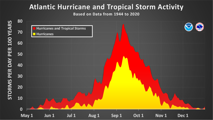
Tropical storm & hurricane formation frequency chart.