
Another cold front is set to sweep across the Florida Peninsula this weekend. This is a strong cold front that will bring another push of Arctic air.
Across the Sunshine State, temperatures will be falling below freezing to start the week, with the northern half of the peninsula and the southern half of Florida in the 30s and 40s.
The cold front has produced strong to severe thunderstorms across parts of the Deep South. But as this front continues to push eastward, much of the instability is going away with it. There is still a chance of some isolated strong to severe thunderstorms across the western portion of the panhandle on Saturday evening.
Showers will continue to move eastward along the I-10 corridor, and we expect scattered thunderstorms to push through the overnight hours into Sunday across North and Central Florida. There’s still a good chance of showers across Southwest Florida and the Treasure Coast by Sunday morning, and showers will be likely across South Florida Sunday afternoon, associated with this cold front.
A strong cold front is about to enter Florida and move from the north to the south. Not enough rain, as we desperately need it, but we do get a few cold nights, starting Sunday night into Monday. pic.twitter.com/OYlVLNofBK
— Florida Public Radio Emergency Network (FPREN) (@FloridaStorms) February 21, 2026
As far as rainfall, we’re not expecting significant amounts across Florida. Remember, we need rain to ease the drought that has worsened over the last few weeks.
At the moment, we forecast between a quarter and half an inch across portions of the panhandle, and because the cold front will be pushing through Florida relatively fast, higher amounts will likely stay focused over the western portion of the panhandle and perhaps some isolated spots across Central Florida that could receive around half an inch or so. For the rest of the state, overall amounts will be below a quarter of an inch.
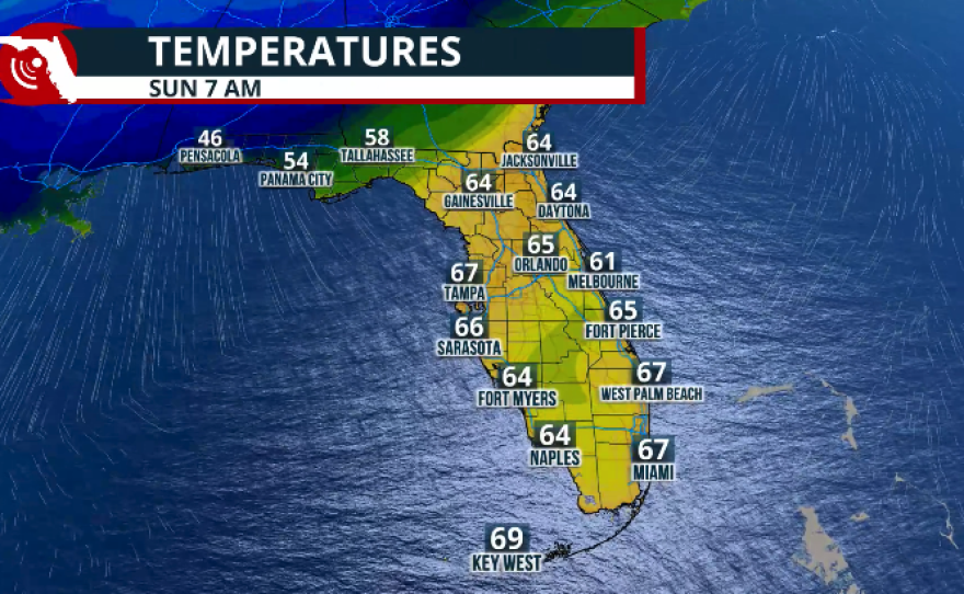
As the cold front pushes through North Florida overnight into Sunday, we will still have to wait until Sunday to start welcoming the cold air. By Sunday morning, there will be a sharp contrast in temperatures between Jacksonville and Pensacola. Pensacola will wake up to temperatures in the mid- to upper 40s, while Jacksonville will still be around the mid- to upper 60s Sunday morning.
Central Florida will still be soupy, with lingering showers and high humidity, which will make the temperatures feel like the upper 60s. Actual temperatures for South Florida on Sunday morning will still be slightly above average, around the upper 60s to low 70s.


Sunday’s forecast
Temperatures will continue to fall on Sunday across the panhandle, with highs remaining around the mid- to upper 50s. Cold air will continue to sink from north to south, and temperatures on Sunday afternoon will actually be falling as it filters through the state.
Around 4 p.m., temperatures across Central Florida will be in the mid- to upper 60s. South Florida will still be toasty and humid, likely dealing with a few showers and temperatures around the upper 70s to low 80s. Once the cold front clears the state, the clouds will dissipate, and temperatures will quickly fall.
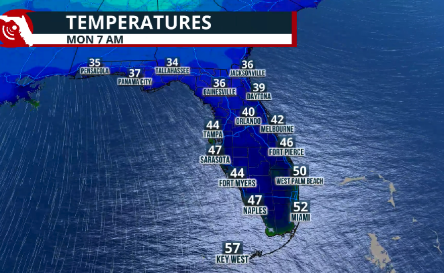
A cold Monday and Tuesday
Monday and Tuesday nights will be very cold across the panhandle, with temperatures falling into the 30s.
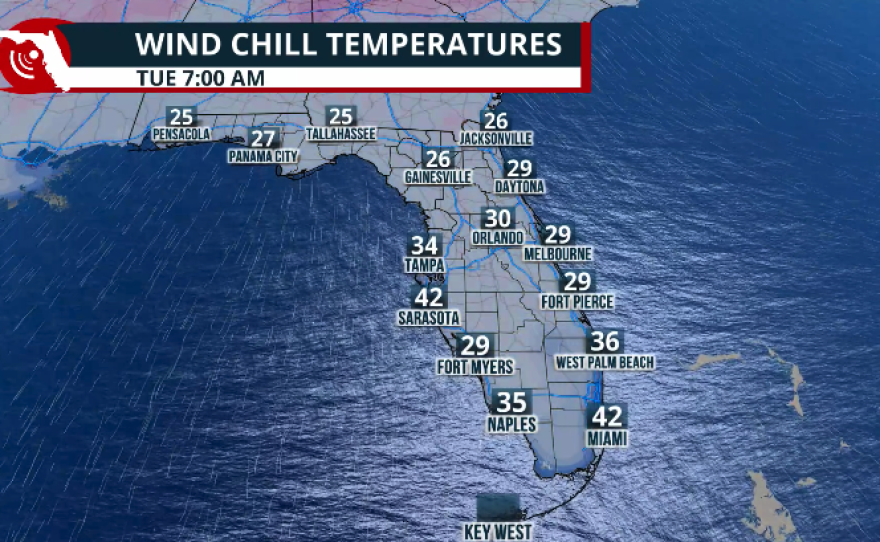
But Tuesday will be the coldest day overall for the entire state, as temperatures will fall into the upper 20s from Pensacola through Jacksonville, stay around the low 30s for the Orlando and Melbourne areas through Daytona, into the low 40s for the Tampa Bay area through Southwest Florida, and across the southeast coast temperatures will be around the mid-40s. Key West will be the warmest point, with temperatures still cold around the low to mid-50s.

Beyond the temperatures
Yes, this will be a cold front that brings cold weather and lets us experience another taste of winter. For the rest of the week, temperatures will slowly climb.
The most worrisome part of this cold front will be the very dry air and the strong winds that will set up camp on Monday and Tuesday.
There is a lot of dry vegetation across the state. The drought has worsened over the last few weeks, and the forecast calls for strong wind gusts that could exceed 30 mph at times, along with very dry air. This is a bad combination for any fires that could develop.

Florida's drought continues to worsen; extreme drought grows by 20 percent.
Please make sure to continue to heed those burn bans that are in effect across many counties in Florida, and any other burn bans that might be in effect across your local area.
There are already red flag warnings in effect, as humidity will be very low and strong winds will be in place, which could allow fires to propagate easily.
Red flag warnings are already in effect across North Florida, starting Sunday afternoon and likely extending through Monday.
A fire weather watch is in effect for the western portion of the peninsula, including the Miami area, starting Monday and continuing through Monday evening. Gusts will be out of the northwest up to 30 mph, and the relative humidity will be below 23%.

JAX issues Red Flag Warning valid at Feb 22, 1:00 PM EST for 32 forecast zones in [FL] and Clinch, Echols, Northeastern Charlton, Southern Ware, Western Charlton [GA] till Feb 22, 9:00 PM EST https://t.co/2JAQxl9BzH pic.twitter.com/PCxPJRZqlP
— IEMBot JAX (@iembot_jax) February 21, 2026


