Bands of rain will continue to impact much of the Interstate 95 corridor through the weekend and into early next week, as forecasters monitor an area of low pressure, which at times could cause conditions that resemble a nor'easter or weak tropical storm.
Ahead of the inclement weather, National Weather Service offices across the state have issued a host of watches and alerts, including Flood Watches from Volusia County southward through the Treasure Coast, and coastal flood alerts that cover much of Northeast Florida.
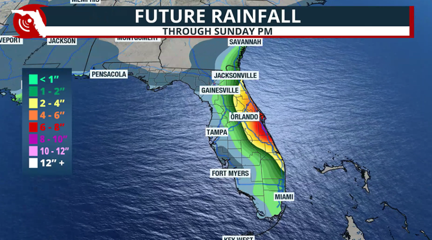
Forecast models indicate rainfall totals of 4 to 7 inches are likely along the I-95 corridor through early next week, with isolated amounts exceeding 8 inches in areas, where rain bands repeatedly train over the same locations.

Inland areas will likely see much lower amounts, with locales between I-75 and I-95 receiving on average 1 to 4 inches, while western parts of the state and the Panhandle may see less than an inch.
Because heavy rainfall combined with high tides could slow drainage, the National Weather Prediction Center has placed much of Florida’s east coast under a Level 1 (Marginal) or Level 2 (Slight) risk for flooding on its four-tier excessive rainfall scale.
Off-and-on showers and thunderstorms are likely to continue into Tuesday until the area of low pressure decides on its next movement.
The National Hurricane Center has given the disturbed area of weather only a low chance of developing, but whether the system organizes or not, the forecast is not expected to change.
In addition to the rainfall, a few of the storms may become strong and even produce an isolated waterspout or weak tornado.
Beach hazards remain
Since the close brush with Hurricane Imelda earlier in the week, seas and surf have elevated with an increased risk of rip currents - dangers that are expected to continue well into next week.
Alerts such as High Surf Advisories, Rip Current Statements and Small Craft Advisories are in effect, reminding boaters and swimmers about the rough conditions.
Additionally, the combination of easterly to northeasterly winds of 20-30 mph will continue to drive coastal erosion, which has been reported in several counties including St. Johns and Palm Beach.
Beach officials in Martin County have even reported swarms of jellyfish, and in addition to flying purple marine flags, lifeguards are flying red flags, which encourage most beachgoers to stay out of the water.
“Please enter the water today ONLY if you are a strong swimmer or experienced surfer! The southern beaches are flying the purple flag as there are still some jellyfish around. If you get stung come to one of the lifeguard towers,” staff with Martin County Fire Rescue stated.
Potential for tropical development
In addition to the area of low pressure that could form either over or near the peninsula, the NHC is also monitoring a disturbance that is exiting the coast of Africa.
Several computer models, including the American Global Forecast System, show the tropical wave organizing late next week while over the central Atlantic.
Due to the possible development, NHC has given the system around a 30% chance of development, which could increase once the time period gets closer.

Most Cabo Verde disturbances that form in the central Atlantic during October tend to recurve well east of the U.S. due to troughs and fall frontal boundaries that in essence act like a wall.
Of course, it is too early to say when or even if the tropical disturbance will develop. The next name on the 2025 Atlantic basin season list is "Jerry."
The hurricane season officially runs through Nov. 30, but tropical cyclones can form at any time of the year if the necessary conditions align.


