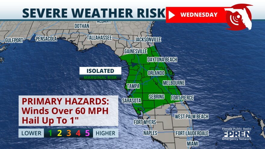
The persistent storms pushed offshore to the east of Central Florida this afternoon, but don’t let your guard down as more rounds of storms will approach the state and pick up intensity in the evening and Wednesday morning. Watch for evening storms moving from north to south affecting the I-10 corridor, and then moving over North Florida during the evening.

Unstable weather continues with several impulses of energy in the upper levels of the atmosphere driving stormy weather across the northern half of Florida. Through late afternoon on Wednesday, the stormy pattern will be courtesy of the next cold front that lacks cold characteristics but will bring plenty of instability to produce the chance for severe weather, especially across the northern half.

Flood threat
Severe weather moved across parts of North Florida triggering several severe thunderstorm warnings and tornado warnings during the morning on Tuesday. Rainfall totals in some spots reached between one- and two inches places between Pensacola and Tallahassee. Areas just to the northwest of Orlando, like The Villages, received slightly more than an inch and a half on Tuesday so far. The rest of North and Central Florida reached between a quarter and half an inch.

The ground continues to be well saturated from the recent rains and storms across north Florida and Central Florida therefore any rain that falls during the next 24 hours could lead to isolated flooding. Rain totals across Central Florida will range between 1 to 2 inches and some isolated areas could receive up to 3 inches of rain. Remember, turn around don’t drown.

Next rounds of storms: timing & intensity
We expect another line of thunderstorms to move just south of I-10 during the late afternoon on Tuesday. Some storms could brush the Panhandle Coast producing damaging winds and there could be some funnel clouds forming along the coast.

The commute home could be a stormy one for parts of North Florida. Gainesville through Jacksonville and all cities in between could be dealing with frequent lightning strikes, storms that produce torrential rains, damaging winds of at least 60 mph and we cannot rule out a tornado or two.
Overnight the storms will continue to slowly drift southward and gradual clearing will happen after 1 a.m. for the Panhandle, from west to east. There could still be some storms affecting the I-4, I-95, and I-75 corridors across Central Florida on Wednesday morning. Some of the storms could turn severe still producing damaging winds, and small hail and some storms could have some rotation. Please heed severe thunderstorms or tornado warnings that might be issued. A warning means you should seek shelter immediately.

On Wednesday afternoon the line of storms will likely affect the Tampa Bay area and parts of Southwest Florida, between noon and 4 p.m. Make sure to monitor the weather forecast closely if you have any plans outdoors. The chance for storms diminishes as this line moves over South Florida on Wednesday, but storm chances pick up on Thursday for Miami-Dade, Broward, and Palm Beach Counties, especially in the afternoon with the sea breezes likely picking up and instability hanging around.

