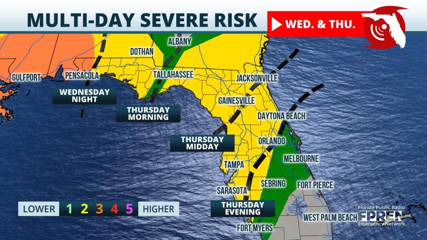
A strong system is expected to bring the potential for tornadoes, wind gusts to 70 miles per hour, and large hail nearly state-wide Wednesday into Thursday.
Surface analysis Tuesday depicts a powerful and dynamic deepening low pushing into the Great Plains.

In the cold sector of this system, blizzard warnings are posted in the northern Great Plains. In the warm sector of this low, an unstable atmosphere has prompted tornado watches for portions of Texas and Oklahoma. Along the attendant cold front, a line of severe thunderstorms was observed moving into the Dallas-Ft. Worth Metroplex. The line of severe- and tornado-warned cells will gradually push east through Tuesday and is forecast to bring continued severe weather to the Lower Mississippi River Valley. Dew points will be on the rise across the Panhandle Tuesday into Wednesday, with model guidance suggesting dew points rise into the upper 60s and lower 70s. The increasing moisture ahead of the line of thunderstorms will provide extra energy to storms that arrive in the Panhandle Wednesday.
Individual cells could initiate as early as midday Wednesday in the Panhandle. These individual cells that do develop will do so in an environment that could support some rotation before the main line arrives. The line of thunderstorms is forecast to move into the Panhandle after sunset Wednesday, likely between 6 and 10 PM local time for locations like Pensacola and Destin. Model guidance takes the line of thunderstorms through the Panhandle during the early morning hours of Thursday, with storms arriving in the Tallahassee area by sunrise. As the cold front pushes east, so too will the line of strong and severe thunderstorms. Storms should arrive in the Jacksonville and Gainesville area by the midday hours, with a weakening trend expected to take place as this initial line outruns instability. Higher resolution model guidance does suggest an additional line of thunderstorms could develop along the main cold front, which would likely persist through the mid-afternoon Thursday. Storms are forecast to generally push offshore and the nearly state-wide threat for severe weather will begin to wind down Thursday evening as cooler and more stable air moves in.
Wind shear and abundant instability will be in place across the Panhandle as storms approach from the west Wednesday evening. Severe thunderstorms often maintain their structure through wind shear, which is a change in wind speed or direction with height. In this week's severe weather potential, winds aloft will be both stronger and in a different direction when compared to the winds at the surface. Wind shear assists in the rotation of individual cells, which explains why the Storm Prediction Center has the far western Panhandle under an "enhanced" risk for severe weather Wednesday. This designation is a 3 on a severe weather scale of 1-to-5 and means that severe storms will be capable of producing stronger and longer track tornadoes. On top of the risk of tornadoes, damaging winds could be in excess of 60 miles per hour and hail could be up to an inch in diameter. By Thursday, the severe weather risk will shift toward the Peninsula as a "slight" risk per the Storm Prediction Center designation. This is a 2 on a severe weather scale of 1-to-5 and means that storms will be widely scattered and capable of producing damaging wind and a few tornadoes. The threat Wednesday into Thursday does drop somewhat, but residents are encouraged not to let this detail bring their guard down.
There is the potential for watches and warnings Wednesday and Thursday. If a watch is issued, it means that the ingredients for severe weather or tornadoes are present in the atmosphere. Watches are typically issued before the weather turns severe and tend to cover a fairly large geographic area for several hours. A warning on the other hand is issued when severe weather is ongoing for a specific location and is typically on a smaller geographic scale, typically covering only a few counties at a time. As a reminder, the severe weather season in the Sunshine State typically does persist through the winter months. This is especially true along the Gulf Coast where powerful cold fronts can sometimes spark stronger storms.
Following the severe weather risk Wednesday into Thursday, a significant cooldown is expected from the Panhandle to Central Florida. Highs for the upcoming weekend fall into the 50s across the Panhandle to the lower and middle 70s across South Florida, as sunshine makes a return to the state.


