-
 The governor says forecasters are calling for a major hurricane. But he says just how strong the storm gets could be determined by the path it takes.
 -
 The region has already been saturated over the past several weeks and the storm is expected to bring up to a foot of rain as it impacts the Big Bend. That’s raising concerns about flooding—and has state and local agencies warning residents not to try to drive through flooded roads.
 -
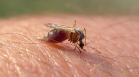 Experts are anticipating a very active hurricane season. That’s good news for the world’s deadliest animal.
 -
 Jeff Berardelli in Tampa and John Morales in Miami say viewer response has been mostly positive. Berardelli says, "We're being irresponsible if we're not providing context."
 -
 The May 10th tornados in Tallahassee damaged and destroyed hundreds of homes and knocked out power. But the extended outages have resulted in a massive amount of food spoilage in a food-insecure area of the state. Now, local residents are restocking their fridges and freezers with help from Second Harvest of the Big Bend.
 -
 The district suffered devastating damage caused by tornados that touched down in the area earlier this month.
 -
 Thunderstorms and at least 3 confirmed tornados barreled through Tallahassee early Friday morning, resulting in at least one local death and leaving more than 80-thousand people without power. The county’s emergency management director is viewing this as a test-run for the upcoming hurricane season.
 -
 Over half of Florida's capitol city is without power as of Friday afternoon.
 -
 About 100 families were temporarily stranded Thursday when flooding caused by a deluge of nearly 10 inches of rain during an overnight storm blocked their ability to leave their property. Many of those families live on Sir Richard Road.
 -
 Strong storms in the forecast have caused some local schools, colleges and universities to close or delay start times Thursday morning.
© 2025 WFSU Public Media
WFSU News · Tallahassee · Panama City · Thomasville
Play Live Radio
Next Up:
0:00
0:00
Available On Air Stations


