-
 La Niña could finally make a comeback this coming winter, this could mean less winter for many across the South.
 -
 Hurricane Milton will be known as one of the most destructive hurricanes to hit Florida in recent history.
 -
 The first significant front of the season sweeps through Florida this week, bringing stable weather that will be good for recovery efforts.
 -
 Hurricane center is watching two areas of development, however things remain calm for now.
 -
 Milton's eye crossed out of Florida Thursday morning into the Atlantic, but the storm continues bringing high winds and downpours to Florida
 -
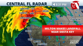 Maximum sustained winds of at least 120 mph at landfall and its winds will gradually decrease but the high risk of flash floods continue.
 -
 Milton is inching closer to the West Coast of Florida, and weather will continue threatening lives across the Florida Peninsula.
 -
 Milton continues to be a very powerful hurricane. It will make landfall late Wednesday or early Thursday. A tornado is forming within rain bands.
 -
 Milton continues as a very powerful hurricane, track still shifting, residents along the path should be sheltered in place.
 -
 Sarasota should monitor Milton's track closely. Milton could come ashore a bit more south than previously forecast.
© 2025 WFSU Public Media
WFSU News · Tallahassee · Panama City · Thomasville
WFSU
1A
WFSU
1A
Next Up:
12:00 PM
Fresh Air
0:00
0:00
Available On Air Stations